 Map of the Universe
Virgo Cluster
Galaxy cluster · Galaxy cluster in the constellation Virgo
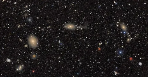
About the Virgo Cluster
The light we see from it set out 0.0537 billion years ago, when the universe was 13.7 billion years old (redshift 0.003727).
The map lists it as a galaxy cluster and shows it at the scale of the large-scale universe, drawn on the supergalactic plane.
The nearest large galaxy cluster: about 1,300–2,000 galaxies, 1.2 × 10¹⁵ solar masses, 16.5 Mpc (54 million light-years) away. The Local Group is falling toward it.
Key numbers
| Distance | 53.82 million light-years (16.50 Mpc) |
|---|---|
| Redshift z | 0.003727 |
| Light travel time | 0.0537 billion years |
| Universe's age when this light left | 13.7 billion years |
| Distance method | redshift-independent (literature) |
| Supergalactic coordinates | SGL 102.3°, SGB -3.1° |
Where it is
Its place in the universe, from the inside out: Virgo Supercluster › Laniakea Supercluster › Observable universe.
Zoom out to see it in context: Virgo Supercluster, a view about 230 million light-years across.
From Wikipedia
The Virgo Cluster is a cluster of galaxies whose center is 53.8 ± 0.3 Mly away in the Virgo constellation. Comprising approximately 1,300 member galaxies, the cluster forms the heart of the larger Virgo Supercluster, of which the Local Group is a member.
Excerpt from the Wikipedia article Virgo Cluster, licensed CC BY-SA 4.0.
Nearby on the map
- Virgo Supercluster Supercluster
- M87 Galaxy
- Antennae Galaxies Galaxy
- Local Sheet Large-scale structure
- Local Void Cosmic void
- Dorado Group Galaxy group