 Map of the Universe
Local Void
Cosmic void · Vast void adjacent to the Local Group
About the Local Void
The light we see from it set out 0.0748 billion years ago, when the universe was 13.7 billion years old (redshift 0.005197).
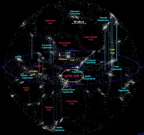
The map lists it as a cosmic void and shows it at the scale of the large-scale universe, drawn on the supergalactic plane.
Its distance or nature is debated, and the map shows one published value.
The empty region next to the Local Group, at least 45 Mpc across (possibly 150–300). Its push and Virgo's pull explain about half our motion relative to the CMB.
Key numbers
| Distance | 75.02 million light-years (23.00 Mpc) |
|---|---|
| Redshift z | 0.005197 |
| Light travel time | 0.0748 billion years |
| Universe's age when this light left | 13.7 billion years |
| Distance method | redshift-independent (literature) |
| Supergalactic coordinates | SGL 86.5°, SGB +85.3° |
| On the map | The dashed circle marks its approximate size around its centre. Structures this large have no sharp edge, and the circle is not drawn to an exact shape. |
| Size | about 196 million light-years across |
Where it is
Its place in the universe, from the inside out: Laniakea Supercluster › Observable universe.
Zoom out to see it in context: Virgo Supercluster, a view about 230 million light-years across.
From Wikipedia
The Local Void is a vast, empty region of space, lying adjacent to the Local Group. Discovered by Brent Tully and Rick Fisher in 1987, the Local Void is now known to be composed of three separate sectors, separated by bridges of "wispy filaments".
Excerpt from the Wikipedia article Local Void, licensed CC BY-SA 4.0.
Nearby on the map
- Local Sheet Large-scale structure
- M87 Galaxy
- Virgo Supercluster Supercluster
- Virgo Cluster Galaxy cluster
- Antennae Galaxies Galaxy
- Dorado Group Galaxy group