 Map of the Universe
Local Sheet
Large-scale structure · Nearby small galaxy filement
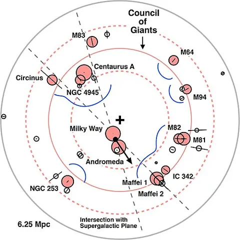
About the Local Sheet
The map lists it as a large-scale structure and shows it at the scale of the large-scale universe, drawn on the supergalactic plane.
The flat wall of galaxies we live in: the Local Group and its neighbours within about 7 Mpc lie in a sheet inclined only 8° to the supergalactic plane, with giant galaxies scattered just 0.23 Mpc above or below its midplane (McCall 2014). The whole sheet moves away from the Local Void at about 260 km/s (Tully et al. 2008).
Key numbers
| Distance | 1.37 million light-years (0.42 Mpc) |
|---|---|
| Distance method | redshift-independent (literature) |
| Supergalactic coordinates | SGL 336.2°, SGB +12.6° |
| On the map | The dashed circle marks its approximate size around its centre. Structures this large have no sharp edge, and the circle is not drawn to an exact shape. |
| Size | about 46 million light-years across |
Where it is
Its place in the universe, from the inside out: Local Group › Virgo Supercluster › Laniakea Supercluster › Observable universe.
Zoom out to see it in context: Virgo Supercluster, a view about 230 million light-years across.
From Wikipedia
The Local Sheet or the Coma–Sculptor Cloud is a nearby galaxy filament and an extragalactic region of space where the Milky Way, the members of the Local Group, and other galaxies share a similar peculiar velocity.
Excerpt from the Wikipedia article Local Sheet, licensed CC BY-SA 4.0.
Nearby on the map
- Virgo Supercluster Supercluster
- Virgo Cluster Galaxy cluster
- M87 Galaxy
- Dorado Group Galaxy group
- Fornax Cluster Galaxy cluster
- Antennae Galaxies Galaxy