 Map of the Universe
Rosette Nebula
Nebula · Emission nebula in the constellation Monoceros
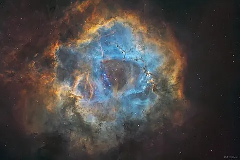
About the Rosette Nebula
The Rosette Nebula is about 5,219 light-years from the Sun, so the light we see from it left about 5,219 years ago.
It is 31,750 light-years from the centre of the Milky Way.
The map lists it as a nebula and shows it among the stars around the Sun, drawn on the plane of the Milky Way.
Key numbers
| Distance | 5,219 light-years (1,600 pc) |
|---|---|
| Distance from the Galactic centre | 31,750 light-years |
| Galactic coordinates | l = 206.50°, b = -1.60° |
| Size | about 130 light-years across |
Where it is
Its place in the universe, from the inside out: Milky Way › Local Group › Virgo Supercluster › Laniakea Supercluster › Observable universe.
Zoom out to see it in context: Local Arm, a view about 12,000 light-years across.
From Wikipedia
The Rosette Nebula is an H II region located near one end of the Rosette Molecular Cloud in the Monoceros region of the Milky Way Galaxy. The open cluster NGC 2244 is closely associated with the nebulosity, the stars of the cluster having been formed from the nebula's matter.
Excerpt from the Wikipedia article Rosette Nebula, licensed CC BY-SA 4.0.
Nearby on the map
- Eskimo Nebula Planetary nebula
- Crab Nebula Supernova remnant
- Crab Pulsar Pulsar
- Double Pulsar Pulsar
- M67 Open star cluster
- Horsehead Nebula Nebula